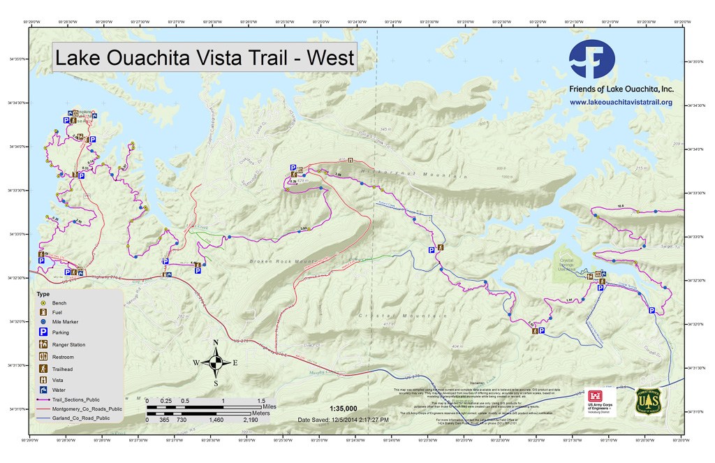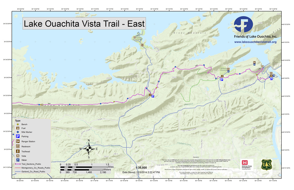
LOViT - An Overview of All Trail Segments
"Trail Segment" naming begins at the western end of the trail segment, except for the Avery Trailhead located at the easternmost terminus of the Trail. The trailhead name is synonymous with the parking area at the trailhead. In the table, we provide the GPS coordinates of the named trailhead. For example, the "Joplin" trail segment's trailhead is located at (34°32′38.8″N, 93°26′41.2″W) and runs generally west to east to the Hickory Nut Mountain trailhead.
| Trail Segment | Trailhead | Length | Difficulty | Handicapped Accessible | Comments and Nearest Accommodations |
|---|---|---|---|---|---|
| Watchable Wildlife | (34°32′37.2″N, 93°28′20.6″W) | 1.25 mile loop | Easy | Yes | Accommodations: Ouachita Shores Resort, Shangri-La Resort, Mountain Harbor Resort, The Joplin Inn at Mountain Harbor, Tompkins Bend Campground near Shangri La Resort, Denby Bay near Ouachita Shores Resort, and Joplin Campground near Mountain Harbor Resort |
| Denby Bay | (34°32′45.9″N, 93°28′51.3″W) | 3 miles to Homestead, 5 miles to Tompkins Bend | Easy to Moderate | No | Accommodations: Ouachita Shores Resort, Tompkins Bend Campground, Shangri-La Resort |
| Homestead | (34°33′40.2″N, 93°28;′22.7″W) | 2 miles to Tompkins Bend | Easy | No | Accommodations: Tompkins Bend Campground, Shangri-La Resort |
| Tompkins Bend Campground | (34°34d′6″ N 93°28′14″ W) | This is a short 0.25 mile spur from inside the Thompkins Bend Campground, joining the LOViT 0.25 mile west of the Tompkins Bend Trailhead | Easy | No | Accommodations: Tompkins Bend Campground, Shangri-La Resort |
| Tompkins Bend | (34°34′6.3″N, 93°28′14.96″W) | 5 miles to the Joplin Trailhead | Moderate | No | Accommodations: Tompkins Bend Campground, Shangri-La Resort |
| Joplin | (34°32′38.8″N, 93°26′41.2″W) | 4 miles to the Hickory Nut Mountain Trailhead | Strenuous | No | Accommodations: Joplin Campgrounds, Mountain Harbor Resort, The Joplin Inn at Mountain Harbor, Lake Ouachita Rentals, Lake Ouachita Vacation Realty (LOVR) |
| Hickory Nut Mountain | (34°33′43.2″N, 93°25′20.7″W) | 3.2 miles to the Forest Service Road 47A Trailhead | Strenuous | No | Accommodations: Joplin Campgrounds, Mountain Harbor Resort, The Joplin Inn at Mountain Harbor, Lake Ouachita Rentals |
| Forest Service Road 47A (FS47A) | (34°32′51.9″N, 93°23′19.7″W) | 2.2 miles by trail, or 1.9 miles by road, to the Pipe Spring Trailhead | Easy to Moderate | No | No accommodations immediately near the trailhead. |
| Pipe Spring | (34°31′55″ N, 93°22′1″ W) | 1.9 miles to the Crystal Springs Pavilion Trailhead | Easy | No | Combines with the Charlton Trail. No accommodations immediately near the trailhead. |
| Crystal Springs | (34°32′28.9″N 93°21′05.5″W) | 1 mile to the parking lot at the Crystal Springs Road Crossing. 3.5 miles to Little Bear Creek between Little Bear Mountain and Bear Mountain. 10 miles from the Crystal Springs road crossing to the Brady Mountain Road Trailhead. | Easy from the Crystal Springs Pavilion to the Crystal Springs road crossing. Moderate to Strenuous across Little Bear Mountain. Strenuous from Little Bear Creek to Brady Mountain Road. | No | This Trail segment Is the longest, beginning at the Pavilion at Crystal Springs, crossing Little Bear and Bear Mountains, and terminating on Brady Mountain Road to the east. Accommodations: Crystal Springs Campgrounds, Crystal Springs Resort, Brady Mountain Resort, Brady Mountain Recreation Area and Campground |
| Crystal Springs Road Crossing | (34°32′10″ N, 93°20′24″ W) | 1 mile from the Crystal Springs Pavilion to the Crystal Springs Road Crossing. 10 miles from Crystal Springs Road to Brady Mountain Road. | Strenuous. No water east of Little Bear Creek. | No | Accommodations: Crystal Springs Campgrounds, Crystal Springs Resort, Brady Mountain Resort, Brady Mountain Recreation Area and Campground |
| Brady Mountain Road | (34°33′31″ N, 93°15′37″ W) | 6.8 milies from Brady Mountain Road to the easternmost terminus of the LOViT at the Avery Recreation area at Blakely Mountain Dam. Just under 4 miles from Brady Mountain Road to Spillway. | Moderate to Strenuous | No | Accommodations: Crystal Springs Campgrounds, Crystal Springs Resort, Brady Mountain Resort, Brady Mountain Recreation Area and Campground, Echo Canyon Marina and Resort |
| Avery Recreation Area at Blakely Mountain Dam | (34°34′4″ N 93°11′35″ W | This is the easternmost terminus of the LOViT. 1.1 miles back to the Blakely Mountain Dam overlook. 2.9 miles from Avery to Spillway Road. | Easy to Moderate from this point back to the Blakely Mountain Dam overlook. Moderate to Spillway. | No | Accommodations: Echo Canyon Marina and Resort, Camping at the Stephens Recreation Area at Blakely Mountain Dam |
Maps of The Lake Ouachita Vista Trail
End-to-End Map (December 2014, 2 pages, about 3.1 MB)
Click here to download a copy of the December, 2014, LOViT map (About 3.1 MB)
Segment Maps (December 2014, about 2 MB each)
- Denby Bay to Hickory Nut Mountain
- Hickory Nut Mountain to Crystal Springs Campground Pavilion
- Crystal Springs Campground Pavilion to Brady Mountain Road
- Brady Mountain Road to Avery