It’s hunting season in Arkansas, and because the Lake Ouachita Vista Trail is primarily located in the Ouachita National Forest, you must be aware of the potential for hunters to be on or near the Trail. Here are the “Hunter Orange Requirements” as published by the International Hunter Education Association: Arkansas (A) It is unlawful to hunt wildlife, or to accompany or assist anyone in hunting wildlife, in zones open to firearm deer, bear, or elk seasons, without wearing an outer garment, above the waistline, of daylight fluorescent blaze orange (Hunter Orange) within the color range of 595-605 nanometers or flouorescent chartreuse color range of 555nm – 565nm (Hunter Safety Green) totaling at least 400 square inches, and a hunter orange or hunter safety green head hat must be visibly worn on the head. (B) Florescent blaze orange (Hunter Orange)or florescent chartreuse (Hunter Safety Green) totaling at least 144 square …Click to read the full article
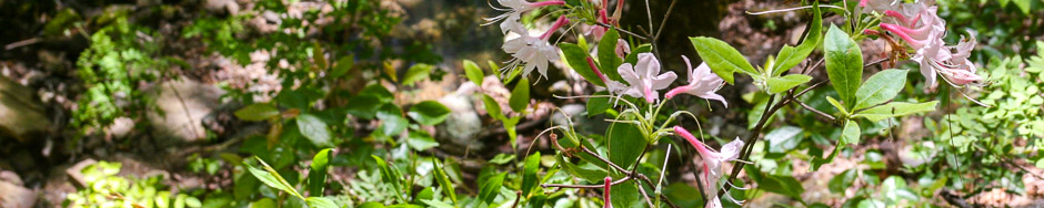
After our “second winter this spring,” we gathered on Hickory Nut Mountain today for a ID & photo hike of the flora on the south slope of the mountain. The second winter had slowed the bloom of the iris and other spring bloomers, but it was a near perfect afternoon for a hike. We had seven hikers for this three mile adventure, again armed with Carl Hunter’s Wild Flowers of Arkansas book and several cameras. After shuttling a vehicle down to the eastern end of this mountainous section, we were off on this really nice downhill hike. Despite the recent rains, the trail was not muddy, and it appeared only a small amount of rain had fallen on the mountain. We did find several old friends blooming along the trail, including the Hairy Spiderwort, Fire Pinks, and Huckleberries laden with blooms. One special find unique in this area was two blooming …Click to read the full article
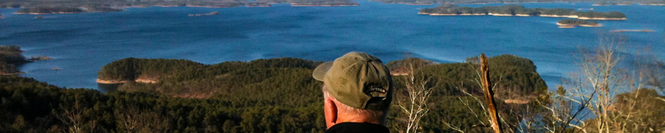
Traildogs are often asked, “Why do you build trails?” We answered that question last Monday, as four seasoned Traildogs – Robert & Georgia Cavanaugh and Gail & Jerry Shields – joined Montgomery County’ s 4-H’ers, lead by County Agent Brad McGinly, at the very popular U.S. Forest Day Use recreation area atop Hickory Nut Mountain for a hike on the LOViT Trail and an old fashioned wiener roast. With spring leaf-out still a few weeks away, the views of Lake Ouachita from the picnic area were inspiring to all who attended. The weather was typical for mid-March, with sunny skies and a light wind, which seemed to further lift the high spirits of the children who were intrigued to be on top of a mountain. The moms and dads who came along remarked that it been a while since they had visited this popular gathering spot and were pleased to find that …Click to read the full article
Traildog Robert Cavanaugh helped a nice group of students from Delta State University in Mississippi and their teacher by providing them with a shuttle and some planning for an overnight hike on the LOViT. The group had originally planned to start Thursday and to spend two nights on the Trail. However, their trip from Mississippi was delayed due to bad weather, so they were only able to camp a single night. Their trip to Hickory Nut Mountain was greeted by plenty of ice on the trees, a pretty view, but a cold day!
Friday, Jan. 11, 2013, we had five Traildogs working the storm cleanup on Section Four Between the trailhead at Hickory Nut Mountain and Forest Service Road 47A. It was good to visit this this 3.2 mile section along the southern face of Hickory Nut Mountain again as it is one of the most scenic sections, especially after a rainfall. Hickory Creek that begins on the summit of the mountain was pure eye candy for our team as we cleared downed trees and limbs. This deep drainage creek creates one waterfall after another as it rushes down the gorge and empties into Lake Ouachita. The area around the artesian spring was highlighted by a set of twin falls just to the north of the spring a sight well worth a hike. We were able to completely clear this section from the Hickory Nut Mt. trailhead to the intersection of U.S. Forest …Click to read the full article
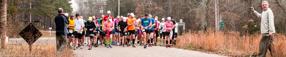
A bunch of Traildogs worked the LOViT Marathon this morning. The race is put on yearly by Phil and Bonnie Carr of Shangri-La Resort. About 70 runners participated this year and enjoyed moderate and overcast weather, perfect for the run. The course begins at the corner of Shangri-La Road and the corner of old Highway 270, proceeds to the Denby Bay Trailhead on the LOViT, and then follows the Trail up to the top of Hickory Nut Mountain, for an out distance of 14+ miles. The return trip takes the cutoff from the Joplin to Tompkins Bend segment across to the Homestead Trailhead, and then back in, accounting for the remaining 12 miles of the marathon. The ‘Dogs working the various aid stations want to thank Bonnie and Varine Carr for supplying the chili and banana pie. Very much appreciated! This was a great event, and everyone, runners and Traildogs, …Click to read the full article
The fall weather this morning was perfect as Traildogs Robert Cavanaugh and Jerry Shields cleared a dozen trees from across the trail on section three (Joplin to Hickory Nut Mountain) and on the old fire tower spur on top of Hickory Nut Mountain. Most of these trees required chain sawing to remove the blockage. The storms that passed through this area in late August and early September brought down several dead spars that had blocked the third section from being fully utilized by mountain bikers. The trail was covered in several places along the trail by small limbs that had been pruned from the hickory trees by a tiny beetle known as a “twig girdler” (Oncideres cingulata). The twig girdler chews the small limbs like a beaver, then drills a hole in the pruned limb and lays its eggs in the limb. See the attached photo of their work. Seems …Click to read the full article
On Feb. 7, 2012, we had seven volunteers assisting in the clearing of the old Fire Tower spur trail and the tower site. The old site was badly overgrown with vines, briars, and numerous fallen trees. After five hours of clearing, we had located the concrete anchors of the tower, the foundation to the watchers’ cabin, a water cistern, and what we believe was a stone cooler used for perishables at the site. We also found the two National Geological Survey medallions installed in 1953. The trail from the Hickory Nut Mountain Trailhead sign to the tower site is only .15 miles and just a ten minute hike from the parking area. The photo gallery below includes a rough proposal for the interpretive sign we plan to install at the site, along with photos of the construction, including the cabin foundation. Jerry