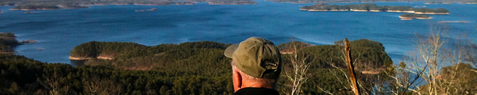
We hope you enjoy your time visiting our website, and that you have a wonderful and safe experience along the Lake Ouachita Vista Trail and the beautiful area through which it runs.
The posts on this "Home" page let you know what's happening on and around the Trail. The rest of the pages on the site introduce you to the Trail segments, the history of the LOViT and of Lake Ouachita, and to the "Traildogs", volunteers who maintain the existing trails and work with the US Forest Service, the US Army Corps of Engineers, and others to create new trail segments. We also include maps of the trails (this is always a work in progress), and we provide information about amenities and places to stay in the area.
Please consider a tax-deductible donation to Friends of Lake Ouachita in support of the Lake Ouachita Vista Trail. Thank you!
The Trail especially needs your help now because of the failure of the Elevated Walkway over Gap Creek and Lake Ouachita.
The Lake Ouachita Vista Trail traverses U.S. Forest lands that have long been popular hunting grounds in all seasons. All Trail users should be aware of these activities and not wear clothing that could be mistaken for wildlife. Bright colors and hunter orange eliminate most instances of mistaken identity. See this Arkansas Game and Fish "Hunting Seasons" link for more information.
We’re happy to announce that there is a set of new Trail maps available for download. You can find these links at the bottom of The Big Picture page. Files are in PDF format and include a single PDF document containing the LOViT East and LOViT West maps, along with a set of segment maps. All maps are relatively high resolution and could be printed on up to 11″x17″ paper. We know of a few changes we need to make, and there are a couple of benches missing from the segment maps, but if you find anything we should know about, please drop us an email or contact us through our Facebook page. Have fun, and be safe on the Trail.
Saturday November 8th was a perfect fall day on Hickory Nut Mountain as six Traildogs met at the Trailhead for some trail maintenance. We had four certified sawyers, myself, Jay Marsh, Dan Watson, and Al Gathright, along with Chuck Dumas with his trusty weed trimmer, and Mike Curran with his historic one man four foot hand saw. Our first order of business was to install the new trailhead sign furnished by the US Forest Service. It took a bit of digging in the stone-infested ground, but we finally concreted in the 6 X 6 post and sign just to the left of the Trailhead map sign. We also cleared all the downed trees and limb debris from the campground located adjacent to the Trailhead. There were two overnight campers in the campground, but the tents’ inhabitants were out taking advantage of the perfect fall weather to enjoy the Trail . …Click to read the full article
One perennial mud hole gone from the trail! After celebrating with the Ouachita Mountain Hikers on Saturday, Oct. 25, I met members of the Boy Scout Troop 262 out of Little Rock at the Tompkins Bend Trailhead parking area. Six Scouts, their troop leader, and several parents joined in to assist Bryan Wornock complete his Eagle rank project of building a 12′ foot bridge about a 3/4 mile east of Shangri-La Road. The team started to work around noon and finished at 5:00 pm, with the new bridge completed and ready for use. Bryan utilized the existing design of our other small bridges to construct the bridge over an area know to bikers and the “Slick Spot” where you can easily take a spill if not careful. Hikers refer to the spot as the “Mud Hole”! We really appreciate the Scouts supporting the Trail! They exemplify the best of young …Click to read the full article
Saturday, October 25th, the Ouachita Mountain Hikers had a rally and BBQ at the Avery Recreation Area to celebrate the completion of their six-day hike of the entire Lake Ouachita Vista Trail system. Starting at the ADA Kiosk on Monday Oct 20th, various groups of OMH members hiked sections of the Trail. Eight of the members, including Traildog Chuck Dumas, received special recognition for hiking the entire forty miles of trail. This was a team effort of the Ouachita Mountain Hikers organization, with some members hiking, some shuttling, and some organizing the Rally and BBQ. The Ouachita Mountain Hikers invited the LOViT Traildogs to join in the hikes and to join them in their celebration rally and BBQ. Pam Harrison served as head chef and food organizer, and it was indeed a feast! Three of our Traildogs – myself, Robert Cavanaugh and Chuck Dumas – were present at the rally …Click to read the full article
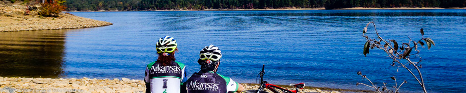
Traildog Robert Cavanaugh had a great day Wednesday, Oct. 22. Zoie Clift of the Arkansas Parks and Tourism Department asked Robert to lead her and two visitors from Italy on a mountain bike ride on the Lake Ouachita Vista Trail. Carlo is a magazine writer and is working on an article on Arkansas. He is a skier and a mountain biker. His friend, Giuliana, is a road biker. Zoie is a very good rider and is a great friend of the LOViT. We spent the day riding the trail, taking pictures, and then finished it up with a great meal at Shangri-La Resort (and a piece of the best banana crème pie in the known universe). A great ride with some very nice people. Click on the image below to view pictures from their time on the LOViT. Carlo has promised a copy of the article when it’s been published. …Click to read the full article
Lake Ouachita Vista Trail Ribbon Cutting Ceremony The Ribbon Cutting Ceremony to officially open the Lake Ouachita Vista Trail (LOViT) has been set for: Date: Tuesday October 28, 1014 Time: 1:00 pm Location: The Avery Recreation Area at the Lake Ouachita’s Blakely Mountain Dam in Garland County. This forty-mile long trail system designed for mountain biking and hiking is the result of ten years of planning, design and construction by a coalition of a dozen local, state and federal organizations. The trail courses along the southern shores of Lake Ouachita over five mountains located in the Ouachita National Forest. The agenda for the ceremony will include remarks by: Colonel John W. Cross, Colonel US Army Corps of Engineers Norman Wagner, Forest Supervisor Ouachita National Forest Joe David Rice, Arkansas Tourism Director Jeff Crow, Deputy Director, Arkansas Game & Fish Commission Steve Schneider, Regional Director, International Mountain Biking Association (IMBA) Following …Click to read the full article
A very good friend of the LOViT and of the Traildogs, Jeff Smith, was tragically killed Friday afternoon, Oct. 10, in a head-on collision on Highway 7 north of the town of Bismarck, AR. Jeff Smith was editor of the Special Sections of the Hot Spring Sentinel-Record and has faithfully reported the story of the building of the Trail now for 10 years, writing a great many articles about our progress. Jeff was a dedicated supporter of the Trail. He came to our first day of construction each year without fail, from year one to our last first day this year. From the Hot Springs Sentinel_Record Facebook page: “Jeff Durand Smith, a valued member of The Sentinel-Record family, was killed early Friday evening in a three-vehicle accident on Highway 7 south near Bismarck in Hot Spring County. “Jeff, the special sections editor for The Sentinel-Record, was well known in the community for his reporting of veterans …Click to read the full article
Oct. 15 was a beautiful fall day for completing some work on the Trail prior to the planned October 28 at 1:00 pm Dedication Ceremony. We had six Traildog volunteers today – myself, Robert, Dan, Chuck, John, and Jeremy – all helping install the new Trailhead sign at the Joplin Trailhead parking area. We also cleared brush and weeds around the parking area and also the section of the Trail heading east where we utilize the old road. We also cleared the weeds from the Trail where it crosses Mountain Harbor Road. Finally, we checked out the ADA Trail for downed limbs and debris. It was a good day to be out on the Trail, and it was nice to have Chris Ham and Tom Ledbetter from the USFS join us at the trailhead. Yesterday, Oct. 14, Traildogs Robert and Dan covered Section 7 of the LOViT from Brady Mountain …Click to read the full article
This past week we had six volunteers assist in the installation of the new trailhead signs at the Brady Mountain Trailhead parking area. It was a challenge to get two deep holes dug in the rock-hard clay soil, but we persevered and were able to install the two 6 X 6 treated poles and attached the six different signs required for the site. It is now virtually impossible to miss this parking area as you drive down Brady Mountain Road. We also attempted to construct the short spur from the parking area to the current trail on the east side of the Brady Mountain Road crossing, but it appears we need the assistance of a mini-excavator to complete this task. We did remove all the trash, brush, downed trees, and weeds from this now-usable spur, but a day with a mini-excavator and a few volunteers would create a better spur …Click to read the full article
(The following article by Martina Kolm was originally published in the Fall, 2014, edition of “Arkansas Wild” magazine. It is reproduced here with Martina’s permission. Martina, thank you for sharing your adventure with us. For more information about Martina and her web design business, visit her site at http://martinasweb.com.) Learning to LOViT With the help of Traildogs and a summer sausage log By Martina Kolm July, 2013 During the brutal ride, everyone switched positions. Clinton, my boyfriend, retook his normal lead; I was second, then Mickey. I stopped to wait; a moment to rest and relish the grandeur of this place. We were enjoying a camping/mountain-biking trip on the Lake Ouachita Vista Trail (“LOViT”) near Mt. Ida, Arkansas. The extensive trail system is 25+ miles with 10+ more planned. [Now, a 45 mile IMBA-designated Epic Trail!] The beautiful mid-day sun poured its light through the canopy, bouncing off white rocks, …Click to read the full article