Bear Mountain Construction – Feb. 2, 2012 – Just A Perfect Day
What an amazing way to spend a early February day! The weather was shirt sleeve and sunny, with only a soft breeze today as we began wrapping up this years construction. The US Forest Service team began removing their excavation equipment today as they move on to other operations in the Ouachita National Forest. It had been our fervent hope that somehow we would be able to push the construction all the way to Brady Mountain Rd. this year, but it appears we have run out of excavation resources.
We measured our progress today as we hiked out at the end of our day, and we have developed three new miles of trail since we started this dig last December. It appears we have approximately 3.5 miles of additional construction to get to Brady Mountain Rd. Budget constraints and other needs of the Forest have brought this year’s construction to end unless we can find additional resources to continue the construction.
We will not be working tomorrow, Feb. 3, but will restart next Monday, Feb 6th.
I will keep you posted as we attempt to secure additional resources.
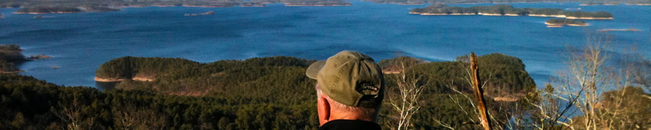
Attached are some photos from where we stopped today’s construction.


Thanks
Jerry
PS. Here’s some track data from where we finished construction for the day to the “ferry”. Click on the “View on Map” link below to see the detail and to access GPS and Google Earth data files for this track.
| Name: | Track 017 | |
| Date: | Feb 2, 2012 1:25 pm | |
| Map: (valid until Jul 31, 2012) |
View on Map | |
| Distance: | 2.30 miles | |
| Elapsed Time: | 43:29.8 | |
| Avg Speed: | 3.2 mph | |
| Max Speed: | 9.4 mph | |
| Avg Pace: | 18′ 55″ per mile | |
| Min Altitude: | 666 ft | |
| Max Altitude: | 1,208 ft | |
| Start Time: | 2012-02-02T19:25:47Z | |
| Start Location: | ||
| Latitude: | 34.554480º N | |
| Longitude: | 93.328224º W | |
| End Location: | ||
| Latitude: | 34.547986º N | |
| Longitude: | 93.349688º W | |