It was a windy day on the mountain as five Traildogs began the final days of finishing work on the mountainous seventh section. We are working just north of the massive tornado blow-down area of May 2011. Tens of thousands of trees were ripped, torn, twisted and destroyed along the northern portion of Brady Mountain Rd. Finding a usable route for the trail was a real challenge, but thanks to the tenacity of U.S. Forest Service personnel, we successfully have threaded the trail between tornado damage and private property. Job well done! The wind today blew in another treat as we working. Suddenly, the air was filled a distant aroma that could only be described as manna from Louisiana, when up the mountain an apparition bearing a foil covered pan of smoking hot Cajun Sausage Bread appeared. Georgia Cavanaugh, Cajun Cook Supreme, brought the Traildog volunteers and the Progressive Trail …Click to read the full article
Today was a day of accomplishments as five Traildog volunteers pushed the trail finishing work over a half a mile west where we joined with the finish work that was completed last month when we were coming in from the west by barge. After a mile and a half hike up the mountain this morning, we set our goal of reaching the point where we ceased operations November 30. A great deal of the tread we were working required only minimal finishing, but there were several extended areas we describe as “gravel pits” that are covered in small to medium stones after the machines finish the new tread. These gravel pits are a pain to finish and require a great deal of fire rake work, followed by root pruning. We did take time to build two rock cairns from some of the moss covered boulders the machine crews had uprooted. …Click to read the full article
We completed another 1/3 of a mile today on Big Bear Mountain, continuing to work our way back to our previous stopping place Nov. 29 when we were coming into the work area from the west. The Progressive Trail Design team has now pushed the trail to within eye-shot of Brady Mountain road. There remains another quarter to a third of a mile before the trail is expected to exit the Forest onto the road, and this last bit of tread will be steep, rocky, and difficult to cut. But, it’s getting there! Today’s work was often in very rocky areas, but toward the end of the day, we broke into an area where the going was relatively easy. The views remain spectacular as we continue to climb, but we will soon be back to “moguls” as we traverse the north side of the mountain just below its summit. Along …Click to read the full article
Only seasoned trail builders show up when the day starts at 19 degrees. Today our four Traildogs competed another 1/4 mile of finish work on the seventh section. We parked on Brady Mountain Road, just north of where the seventh section will intersect the road, and hiked up to where our machine crew from Progressive Trail Design were busy carving out the final mile of the seventh section. It only required a hike of about 25 minutes to intersect the roughed in trail. We are working back west toward where we stopped last week while the machine crew continues on east. The trail is mostly soil, clay, and small stones and is not difficult to work. We’re hoping to make good progress tomorrow. We are about a mile east of where we stopped last week. The machine crew is less than a mile from Brady Mountain Road. We will meet …Click to read the full article
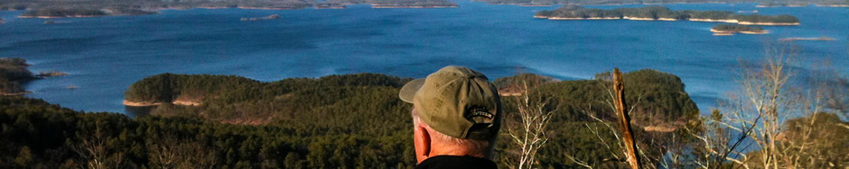
Friday we reached a key milestone for this fall’s dig – the halfway point of the planned 4.2 miles of new trail, along the northern face of Big Bear Mountain. The portion of the seventh section is a rolling, winding trail that snakes along just below the northern summit of Big Bear Mountain as it goes around large rock outcropping, boulders and old growth hardwoods. The completed product, as you look back on your finish work, has a beautiful, natural patina of fresh earth and fallen leaves. The new trail looks like it belongs there and is an enhancement to a serene stretch of remote woodland overlooking the sparkling waters of Lake Ouachita. The new Traildog Vista that peeks through a wide break in the forest canopy is a must stopping point for any user and will be one where a million Kodak Moments will be shot. At the end …Click to read the full article
Lake Ouachita Vista TrailPosted on by Al Gathright
Nov. 28 It was an eerie start to the day as a dense fog hung low in the Crystal Springs Marina Basin. Capt. Dan expertly steered us to our destination. Four Traildogs groomed .27 miles. The total distance of new groomed trail is now 1.41 miles. The Traildogs also removed a dead tree near the new bench at Traildog Vista. The crew from Progressive Trail Design is about a mile ahead of us. Now that the crew is back on their pace, they predict a Dec 7 completion date. They have about 1.5 miles remaining. USFS staff, Tom Ledbetter, Jake Raines and Chris Ham were on the trail today. Their mission was to replace trial course flagging that recently disappeared. Thursday and Friday will be the last work days until the dig crew reaches Brady Mtn Road. It is currently a 4 mile ATV ride one way to our work site. …Click to read the full article
New Signs at Pipe Spring We recently installed a new trail directional sign at the pipe spring on USFS 47 where the Charlton and LOViT trails merge, about two miles west of Crystal Springs Road. We have been receiving feedback from users that they are confused on where the Charlton goes and the LOViT goes from this point. Hopefully this will solve those issues. Bear Mountain Construction – Crystal Springs to Brady Mountain We finalized our construction plans for this fall’s dig on the second half of the seventh section of the trail. The Progressive Trail Design team will arriving on site on Monday, October the 29th. They will begin construction, working from where we stopped construction last February, and will move east toward Brady Mountain road about 4.0 miles from our previous stop position. This dig team will be leaving a more finished trail that will require the …Click to read the full article
Four hardy Traildogs today participated in the layout and flagging of the final section of the trail. Starting at where the trail will cross Spillway Rd., we threaded our way through the narrow gap of public land between the lease land of the Spillway Resort, now called “Echo Canyon Resort and Marina“, and a plot of private land to the south. Our team was able to find the property corners of the private land which served as the south boundary of our layout. We flagged the trail about a 100 yards north of the private land and well outside the boundary of the Echo Canyon Resort lease land. Once we passed through this gap we took the trail along a ridge that led to the new road leading up to the Corp of Engineers new administration building located atop the mountain on the west side of the dam. We located …Click to read the full article
Last week, Traildog Mike Curran hiked the area between Brady Mountain Road and Blakely Mountain Dam in which the 8th and final segment of the LOViT will be laid out and built. While some areas have been devastated by tornados, Mike did provide Jerry with a number of photographs from his wanderings. This photo is one from his hike to give us some idea of what we have to look forward to.